Mount Snowdon (named in welsh-Yr Wydffa) is the highest mountain Wales with an elevation of 1,085 metres (3,560 feet) above sea level making it the highest mountain in the British Isles if you exclude the Scottish highlands. It is one of the mountains climbed as part of the national three peaks challenge along with Ben Nevis (Scotland's highest at 1,345m) and Scafell Pike (England's highest at 978m).
There several Paths/Routes to the Summit of Snowdon-
(Information Gathered from several internet sources)
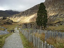
Llanberis Path (The path we took)
9 miles (14 km) long Llanberis Path has the shallowest gradient and is the longest route to the summit. It follows the line of the railway and is considered one of the "easier" routes to the summit (why we chose it) which make it the most popular path to take and the most visited annually in the UK. It is said to take 4-7 hours to reach the summit.

The path starts in Llanberis near to the Royal Victoria Hotel, you cannot see the summit from here. It climbs towards Hebron Station with great views back towards Dinorwig Slate Quarry and Elidir Fawr. You continue to Halfway House, with wonderful views of Moel Cynghorion, Foel Goch, Foel Gron, Moel Eilio and the Cwm Brwynog valley. At Halfway House you can purchase refreshments in the summer months (we couldn't as we did it in the middle of the night and it was closed). The next stage ascends towards Cwm Glas Bach with views of the Llyn Du'r Arddu lake. The final section takes you from Bwlch Glas to the summit where there are magnificent views over Snowdonia, Ireland, the Isle of Man, the Peak District and the Lake District.
The section of the Llanberis Path beside the railway near the summit has been called the "Killer Convex"; in icy conditions, this convex slope can send unwary walkers over the cliffs of Clogwyn Du'r Arddu. Four people died there in February 2009.
Snowdon Ranger Path
 The Snowdon Ranger path begins at the Youth Hostel beside Llyn Cwellyn, to the west of the mountain, it is thought to be the oldest path to the summit.
The route begins with zigzags through turf, before reaching a flatter boggy area in front of Llyn Ffynnon-y-gwas. The path then climbs to Bwlch Cwm Brwynog, and then snakes along the ridge above Clogwyn Du'r Arddu towards the summit. This path meets the railway, the Llanberis Path, the Crib Goch path, and the combined Pyg Track and Miners' Track all within a short distance, just below the summit.
Rhyd Ddu Path
The Rhyd Ddu path, also called the Beddgelert Path, leads from the village of Rhyd Ddu, west of Snowdon, gently up on to Llechog, a broad ridge dropping west from the summit. It is considered one of the easier routes to the summit, with the advantage that the summit is visible from the start, but is one of the least used routes. It climbs at a shallow gradient to Bwlch Main, shortly southwest of the summit, from where it climbs more steeply, meeting up with the Watkin Path at a site marked with a large standing stone a few hundred metres from the summit.
The Watkin Path
The start of the Watkin Path has been described as "the prettiest beginning" of the routes up Snowdon. It begins at Bethania and climbs initially through old woodland, After leaving the woods, the path climbs past the waterfalls of the Afon Llan to the glacial cirque of Cwm Llan, crossing a disused incline from an abandoned slate quarry. It then reaches Plas Cwmllan,
From the slate quarries, the Watkin Path veers to the north-east to reach Bwlch Ciliau, the col between Snowdon and Y Llilywed, which is marked by a large orange-brown cairn. From here, it heads west to meet the Rhyd Ddu Path at a standing stone shortly below the summit of Snowdon.
Over Y Lliwedd

The route Over Y Lliwedd is more frequently used for descent than ascent, and forms the second half of the Snowdon Horseshoe walk, the ascent being over Crib Goch. It is reached by following the Watkin Path down to Bwlch y Saethau, and then continuing along the ridge to the twin summits of Y Lliwedd. The path then drops down to Cwm Dyli to join the Miners' Track towards Pen-y-Pass.
Miners' Track


The traverse of Crib Goch has been described as "one of the finest ridge walks in Britain", and forms part of the Snowdon Horseshoe, a circuit of the peaks surrounding Cwm Dyli. The path follows the Pyg Track before separating off from it at Bwlch y Moch and leading up the East ridge of Crib Goch. All routes which tackle Crib Goch are considered mountaineering routes or scrambles.
Pyg Track
The Pyg Track also leads from Pen-y-Pass. The track climbs over Bwlch y Moch on the eastern flanks of Crib Goch, before traversing that ridge's lower slopes. Above Glaslyn, it is joined by the Miners' Track for the zigzag climb to Bwlch Glas between Snowdon and Garnedd Ugain.
The Summit
At the Summit of Snowdon, there is a station for the railway, a shop, a Visitors centre and a cafe, all of which were closed because of the time we climbed. At the very top of the summit stands several dozen steps that lead to plinth, where thousands of summit reachers take their photos to "prove" they have made it.
Here's mine:

No comments:
Post a Comment